How to Measure Agricultural Land in India? Land Area Calculation & Measurement Units!
Published on October 13, 2025

Agriculture land area calculation may not sound exciting, but it’s one of the most important aspects of farmland ownership in India. Whether you’re buying, selling, or managing agricultural property, understanding how to measure agricultural land accurately ensures fair value, legal clarity, and proper planning.
Because in India, measuring land isn’t as simple as taking out your phone and using Google Maps. Nope. It’s a beautiful chaos of bighas, kathas, guntas, acres, and hectares, each telling its own regional story.
What’s called a bigha in one state could mean half of that in another.
But why does it matter? Because accurate agriculture land measurement decides everything. from buying and selling property, setting up irrigation systems, to even calculating yields and taxes.
So, in this blog, let’s break it all down. the traditional measurement units, the modern tools, and a few smart tips to help you figure out how to measure total cultivable land like a pro.
Let’s roll up our sleeves. This one’s going to be both old-school and tech-smart.
Traditional Agricultural Land Measurement Units in India
Because when it comes to agricultural land measurement, India doesn’t play by one single rulebook. We’ve got a patchwork of traditional land measurement units that change faster than the weather . depending on which state you’re standing in.
Let’s start with the basics:
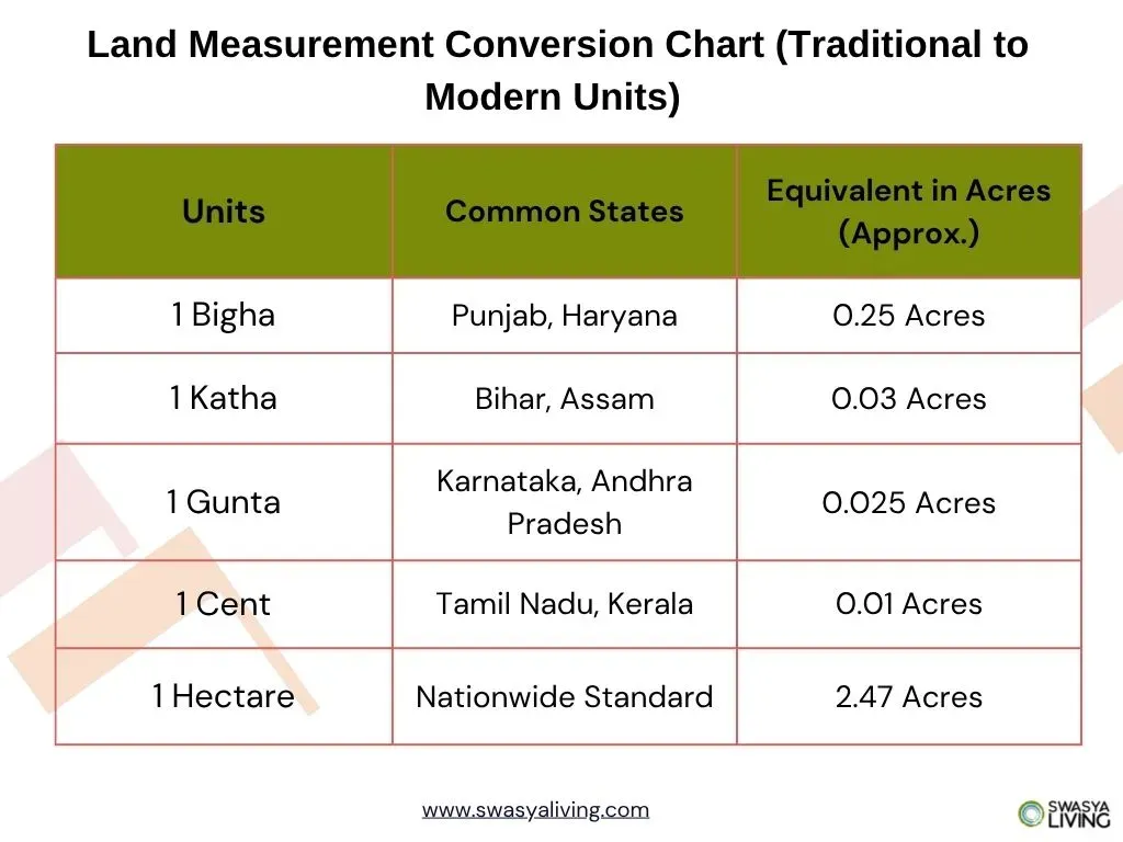
- Bigha – The most famous one! But also the most confusing. In Punjab and Haryana, one bigha equals roughly 0.25 hectares. But drive down to Uttar Pradesh, and it could mean anywhere from 0.25 to 0.33 hectares. Basically, it’s a shape-shifting unit that keeps surveyors on their toes.
- Katha – Popular in Bihar, West Bengal, and Assam. The size? Also variable. Around 1361 sq. ft. in Bihar, and 720 sq. ft. in Assam.
- Gunta – If you’re in Karnataka or Andhra Pradesh, this one’s your go-to. One gunta = 1089 sq. ft. (yes, people still use it in sale deeds!).
- Kanal & Marla – Up North in Jammu, Punjab, and Himachal, this duo rules the roost. One kanal = 5445 sq. ft., and one marla = 272.25 sq. ft.
- Cent – Head down South to Kerala or Tamil Nadu, and you’ll hear about “cents.” One cent = 435.6 sq. ft. (and 100 cents make one acre).
And this is just the tip of the iceberg. Every region has its own agricultural land measurement units, shaped by old customs and local land systems.
The good thing? These units have cultural value. they connect generations of farmers who measured their lands long before GPS or GIS came into play. The not-so-good thing? They can cause major confusion when you’re trying to convert one into another.
But don’t worry. that’s why we also have modern systems that are far easier to calculate (and way less headache-inducing). Let’s get into those next.
Modern Agricultural Land Measurement Standards in India
While our grandfathers probably measured land by pacing across the field or using a stick marked with “bamboo lengths,” today’s farming scene has gone full tech mode. We’ve officially entered the “no more guesswork” era of agriculture land area calculation.
Let’s talk about the modern measurement units. The ones you’ll find in land records, government papers, or property registration documents:
- Square Meter (m²) – This is the gold standard now. Every modern land survey, urban planning project, or agricultural plot record uses this.
1 sq. meter = 10.76 sq. feet - Hectare (ha) – The big boss of agricultural land measurement. One hectare = 10,000 square meters, or about 2.47 acres. Most government data about farmland productivity or crop yield is recorded in hectares.
1 hectare = 2.47 acres - Acre – Old, yes. Irrelevant? Absolutely not. One acre = 43,560 square feet, and it’s still one of the most common land measurement units in India, especially among farmers.
1 acre = 4,047 sq. meters - Square Kilometer (km²) – This one’s for the big leagues. forest lands, regional surveys, or massive agricultural estates. One km² equals 100 hectares.
Now why do these matter? Because if you’re trying to sell, lease, or even just register your agricultural property. your documents, tax records, and agreements must use these standardized units. It avoids confusion, reduces disputes, and keeps everything nice and clean in the official system.
Plus, when you know how to convert traditional units into these modern ones, you can instantly figure out how much cultivable land you actually have. no more confusion about “how do you measure total cultivable land?” or “what’s the standard unit of measuring agricultural land?”
Think of it like switching from an old Nokia to a smartphone. once you go modern, there’s no going back.
Tools and Technology for Agriculture Land Area Calculation
Nobody wants to spend hours under the sun squinting at measuring tapes and arguing whether “this mango tree” marks the boundary or “that one over there.” Those days are gone. Measuring land has gotten smart, fast, and surprisingly cool.
If you’ve ever wondered how surveyors pull off those pinpoint-perfect agriculture land measurements, here’s the secret sauce
- GPS Devices – Yup, the same technology that helps you find the nearest chai stall now helps farmers and landowners map out exact boundaries. You can get your plot’s coordinates right down to a few meters of accuracy.
- Total Stations – Think of this as a supercharged digital theodolite. It combines laser distance measurement and angle calculation to create highly accurate 3D maps of your land. Perfect for large farms or uneven terrains.
- Drones – My personal favorite. These little flying geniuses can capture aerial footage and generate stunningly accurate 3D maps of your farmland. Some even use AI to analyze soil types and slope patterns.
- GIS (Geographic Information Systems) – Sounds fancy, right? It basically helps store, analyze, and visualize land data. If you’ve got multiple plots, GIS gives you the big-picture view.
- Laser Rangefinders – Handy for smaller plots. Just aim, click, and it tells you the distance. Great for quick checks or cross-verifying old records.
So yeah, if you’re planning to buy land, verify your boundaries, or calculate your agriculture land area, these tools are total game-changers.
Step-by-Step Guide: How to Measure Agricultural Land Area
You’ve got your land, your measuring tools, now how do you actually figure out how much cultivable land you have? Here’s my simple breakdown:
- Start with the Survey Sketch – Before anything, get your land’s survey sketch or FMB map. It’s basically the blueprint of your property.
- Mark the Boundaries – Walk the perimeter and mark the corners. Use pegs, stones, or even flags if the area is big. This helps you visualize the real space.
- Measure the Sides – For rectangular plots, it’s easy. measure length × width. For irregular plots, break it into triangles or rectangles and measure each part.
- Convert Traditional Units – If your records say “10 guntas” or “1.5 bighas,” convert them into hectares or acres so everything aligns with modern units.
- Use Tech Tools – GPS apps, laser rangefinders, or even drones can help cross-check your calculations. Trust me, it makes life way easier.
- Calculate the Total Area – Add all measured parts together and you’ve got your agriculture land area calculation done.
Once you master this, you’ll never be confused about how to measure total cultivable land again. It’s satisfying, precise, and honestly kind of fun when you see the numbers add up perfectly.
Common Challenges in Agriculture Land Area Calculation
It’s not always smooth sailing. Measuring land in India can be tricky, and here’s why:
- Confusing Units – One region’s bigha isn’t the same as another’s. Mix that with gunta, katha, or cent, and you’ve got a mini puzzle.
- Outdated Records – Old survey maps or land deeds might not match reality. Trees fall, boundaries shift, and suddenly your sketch is off.
- Human Error – Even pros make mistakes. One misstep with a tape or GPS can throw off the whole calculation.
- Rough Terrain – Hills, forests, and uneven fields make accurate measurement tough. You can’t exactly stretch a tape over a stream!
- Legal Confusion – Inconsistent documentation or multiple owners can lead to disputes if you don’t measure and record properly.
The takeaway? Always double-check your measurements, use modern tools alongside traditional knowledge, and keep clear records. Measuring agricultural land is half science, half detective work . the more thorough you are, the fewer headaches later.
Conclusion: Simplifying Agricultural Land Area Calculation in India
From bighas to hectares, from tapes to drones, measuring agricultural land in India might seem like a maze, but it doesn’t have to be. Once you understand the traditional units, the modern standards, and a few smart techniques, calculating your agriculture land area becomes straightforward.
Remember, whether you’re buying, selling, or just managing your farm, accurate land measurement saves you time, money, and future headaches. It’s like laying a solid foundation before you start building. everything else flows smoothly from here.
And speaking of laying foundations, if you’ve ever dreamed of owning a piece of land that’s ready for farming, future-ready, and nestled in a nature-rich community, Swasya Living is doing exactly that. From Sakleshpur to new projects expanding to other serene locations, we combine sustainable living with smart planning, making it easier than ever for you to own and manage your agricultural land, hassle-free.
So, measure smart, plan right, and let your land truly work for you.
Learn more about buying agricultural land in Karnataka or explore our Swasya Living farmland projects to experience sustainable living and modern farmland management.
